 Skip to content

How to Travel from Quito to Guayaquil Exploring the Avenue of the Volcanoes?
Traveling between Ecuador’s two largest cities—Quito in the high Andes and Guayaquil on the Pacific coast—is one of the most rewarding overland journeys in South America. Instead of taking a quick 50-minute domestic flight, taking five days to travel south through the famous Avenue of the Volcanoes allows you to experience dramatic mountain landscapes, crater lakes, indigenous markets, and lush cloud forests.
Coined by the German explorer Alexander von Humboldt in the early 19th century, the Avenue of the Volcanoes refers to the fertile central valley flanked by over thirty volcanic peaks. This 5-day overland route provides a seamless transition from the high-altitude Sierra to the tropical coastal lowlands of Guayaquil.
5-Day Avenue of the Volcanoes Itinerary Map
- Day 1: Quito ➔ Cotopaxi National Park ➔ Lasso / Cotopaxi Foothills
- Day 2: Cotopaxi ➔ Quilotoa Crater Loop ➔ Chugchilán or Tigua
- Day 3: Quilotoa ➔ Baños de Agua Santa (Waterfalls & Cloud Forest)
- Day 4: Baños ➔ Chimborazo Wildlife Reserve ➔ Riobamba
- Day 5: Riobamba ➔ Ingapirca Ruins (Optional) ➔ Guayaquil
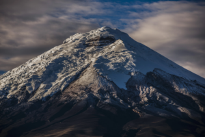
Day 1: Quito to Cotopaxi National Park – Touch the Glaciers
Your journey begins early in Quito, heading south along the Pan-American Highway. Within two hours, the skyline changes from urban architecture to rolling pine forests and towering peaks. Your first major destination is Cotopaxi National Park, home to one of the highest active stratovolcanoes in the world (5,897 meters / 19,347 feet).
Key Highlights for Day 1:
- Limpiopungo Lagoon: A tranquil high-altitude lake located at 3,800 meters (12,467 feet). It offers flat walking trails and excellent opportunities to photograph wild Andean horses, caracaras, and the reflection of Cotopaxi on the water.
- Hike to José Rivas Refuge: For active travelers, drive up to the parking lot at 4,500 meters (14,763 feet) and hike up to the refuge at 4,864 meters (15,958 feet).
- Overnight Stay: Stay at a historic hacienda near the park entrance, such as Hacienda San Agustín del Callo or Hacienda La Cienega, where you can enjoy locro de papas (traditional potato soup) by a roaring fireplace.
Traveler Tip: Proper acclimatization is essential. Drink plenty of water, sip local coca tea, and take slow steps when hiking at high altitudes.
Day 2: The Quilotoa Loop – Emerald Waters & Indigenous Culture
On day two, leave the main highway and venture west into the rugged backcountry roads of the Quilotoa Loop. This region is famous for its steep canyons, terraced farmland, and vibrant indigenous communities.
Key Highlights for Day 2:
- Tigua Art Galleries: Stop along the highway in Tigua to visit local artisan workshops. Tigua paintings are renowned worldwide for their bright acrylic colors on sheepskin canvases depicting Andean rural life.
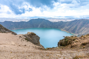
- Quilotoa Crater Lake: Arrive at the rim of Quilotoa, a massive 3-kilometer-wide water-filled caldera. The lake’s striking emerald-green water shifts shade depending on the sunlight.
- Activities at the Crater: Walk along the rim trail for panoramic photos, or hike down the zig-zagging path to the water’s edge, where you can rent kayaks. (Mule rentals are available for the steep climb back up).
- Overnight Stay: Sleep in a cozy eco-lodge in the nearby village of Shalalá or Chugchilán.
If you want an expert team to handle your mountain transport, mountain guides, and lodge reservations, explore our fully custom overland routes on Columbus Ecuador.
Day 3: Baños de Agua Santa – Adventure in the Gateway to the Amazon
From the quiet highlands of Quilotoa, head southeast toward Baños de Agua Santa. Located in a valley at the base of the active Tungurahua Volcano, Baños marks the transition zone where the high Andes plunge down toward the Amazon basin.
| Activity | Location | Highlights |
| Route of the Waterfalls | Ruta de las Cascadas | Scenic drive along the Pastaza River canyon featuring zip-lines and cable cars (tarabitas). |
| Pailón del Diablo | Rio Verde | A massive, roaring waterfall with carved stone steps that lead you behind the cascading water. |
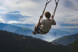
| Swing at the End of the World | Casa del Árbol | A famous hilltop swing offering unobstructed views of Tungurahua Volcano. |
| Thermal Baths | Town Center | Natural hot springs heated by underground volcanic activity, perfect for evening relaxation. |
Overnight Stay: Stay at a spa hotel in Baños and enjoy fresh trout or local sugar cane sweets (melcochas).
Day 4: Chimborazo Reserve to Riobamba – The Closest Point to the Sun
On day four, travel southwest toward the massive Chimborazo Wildlife Reserve. Mt. Chimborazo (6,263 meters / 20,548 feet) is the highest peak in Ecuador. Because of the Earth’s equatorial bulge, its summit is officially the closest point on Earth to the sun.
Key Highlights for Day 4:
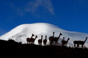
- Vicuña Spotting: The high-altitude plains (páramo) surrounding Chimborazo are home to thousands of protected vicuñas—the wild, graceful relatives of llamas and alpacas.
- Carrel Refuge Hike: Drive up to the lower refuge at 4,800 meters (15,748 feet) and take a short walk up to the Whymper Refuge at 5,000 meters (16,404 feet) for impressive views of giant glaciers.
- Riobamba City Tour: Head down to Riobamba, a historic city known as the “Cradle of Modern Ecuador.” Walk through Plaza de la Concepción and admire the colonial architecture.
Planning a broader trip? You can easily combine this 5-day overland route with an extension to the coast or an island expedition. Browse our combined wildlife and mainland packages on Columbus Ecuador.
Day 5: Riobamba to Guayaquil – Descending to the Pacific Coast
Your final day takes you from the cold Andean highlands down to the warm, tropical lowlands of the Pacific coast. As you descend, the landscape changes from alpine meadows to lush cloud forests, cocoa plantations, and banana groves.
Key Highlights for Day 5:
- Optional Stop at Ingapirca: If time permits, take a slight detour south to visit Ingapirca, the largest known Inca archaeological site in Ecuador, featuring the elliptical Temple of the Sun.
- Chocolate Tasting En Route: Stop at an organic farm in the coastal foothills to learn how Ecuador produces some of the world’s finest fine-flavor cacao (Arriba Nacional).
- Arrival in Guayaquil: Arrive in Guayaquil by late afternoon. Walk along the Malecón 2000 boardwalk beside the Guayas River, explore the colorful historic neighborhood of Las Peñas, and visit Iguana Park (Parque Seminario) to see dozens of land iguanas roaming freely.
Why Choose an Overland Trip Over Flying?
- Zero Waste Days: Turning a transit day into a multi-day sightseeing expedition maximizes your vacation time.
- Gentle Acclimatization: Gradual changes in elevation help your body adjust to the high altitudes of the Andes.
- Cultural Immersion: Direct access to indigenous artisan markets, family-run haciendas, and local cuisine that air travelers miss entirely.

Frequently Asked Questions (FAQs)
Here are the most common questions travelers ask
How do you travel from Quito to Guayaquil overland?
The best way is by private driver or guided tour along the Avenue of the Volcanoes (Pan-American Highway South). This route takes you past Cotopaxi, Quilotoa, Baños, and Chimborazo before descending to the coast. Public buses also run the route, but they do not stop at national park trails or scenic crater viewpoints.
Is it safe to drive on the Avenue of the Volcanoes in Ecuador?
Yes, driving the main Pan-American Highway (E35) is safe and well-paved. However, mountain roads can experience heavy fog, rain, or occasional landslides. Hiring a professional driver or booking a guided tour with Columbus Ecuador ensures a stress-free journey with an experienced local navigator.
What is the best time of year to explore the Avenue of the Volcanoes?
The dry season in the Ecuadorian Andes runs from June to September, offering the clearest skies and best mountain views. However, the region can be visited year-round. Mornings are generally clear, while afternoons often bring cloud cover or light rain.
What should I pack for a 5-day Quito to Guayaquil road trip?
Because you will experience both chilling mountain weather and warm tropical climates, you must pack in layers:
- Thermal base layers, a fleece jacket, and a windproof/waterproof coat for Cotopaxi and Chimborazo.
- Comfortable hiking boots and thick socks.
- Sun protection (high-SPF sunscreen, sunglasses, and a hat—the equatorial sun is intense at high altitudes).
- Lightweight clothing, shorts, and sandals for your arrival in humid Guayaquil.
How many days do you need to see the Avenue of the Volcanoes?
While you can drive directly from Quito to Guayaquil in 8 hours, 5 days is the ideal timeframe to comfortably explore the major national parks, hike around crater lakes, enjoy thermal hot springs, and visit indigenous markets without feeling rushed.